
Laura Weiwu
Assistant Professor
Haas School of Business
UC Berkeley
2220 Piedmont Ave
Berkeley, CA 94720
[[lauraww@berkeley.edu||mailto:lauraww@berkeley.edu]]
[[ [Curriculum Vitae]||/assets/files/Laura_Weiwu_CV.pdf]]
I am a labor and urban economist at UC Berkeley. My research focuses on the causes and consequences of inequality in the United States, often combining insights from spatial economics and economic history to better understand how place and policies of the past shape economic outcomes.
I received my Ph.D. in Economics from MIT in 2024, and my B.A. in Economics and B.S. in Applied Mathematics from Stanford in 2018. Before joining Berkeley, I was a postdoctoral fellow at Stanford.
As a graduate student, I also worked at the Census Bureau’s Center for Economic Studies to build new measures of intergenerational mobility for the mid-20th century.
Name pronunciation tip — my last name is two Chinese characters (危吴) and spoken as way-woo
Working Papers
Unequal Access: Racial Segregation and the Distributional Impacts of Interstate Highways in Cities
Revision requested at American Economic Review
This paper measures the Interstate Highway System's impact on welfare inequality in cities separately by race and education. I quantify the incidence of commute benefits from connecting residences to workplaces, costs where highways are built, and equilibrium responses using novel data on commuting and historical maps nationwide. Given the concentration of benefits in suburbs and costs in the urban core, differential suburbanization by race, more pronounced than by education, contributes to racial gaps in welfare gains. Using a spatial equilibrium framework, opening access to peripheral areas for minority families eliminates the majority of the gap while preserving aggregate welfare improvements.
Best Student Paper, Urban Economics Association.
Allan Nevins Dissertation Prize, Economic History Association
Opportunity in Motion: Infrastructure, Job Access, and Intergenerational Mobility
This paper studies how transportation infrastructure improves job access and, in turn, shapes neighborhood economic development and the intergenerational outcomes of children. I use a newly linked administrative dataset covering the near-universe of families with children born between 1964 and 1979. Increased commuting access from Interstate highway construction raises average neighborhood income through both direct income gains for existing residents and compositional changes driven by selective migration. Using a movers design, I show that increases in neighborhood income benefit children and reduce intergenerational inequality, with larger gains for children from lower-income families. However, migration responses generate negative spillovers: areas with smaller access improvements experience declines in peer quality, adversely affecting children in those locations. I develop an accounting framework to quantify the aggregate effects on intergenerational mobility and find that the direct economic benefits of improved access outweigh these negative spillovers. Nevertheless, changes in neighborhood composition increase the spatial inequality of opportunity.
Russell Sage Foundation Pipeline Grant, Upjohn Institute Early Career Research Award
Measuring Winners and Losers from Increasing Housing Supply
with Vincent Rollet
Local governments often restrict the construction of new housing through zoning and permitting hurdles. This resistance suggests that increasing the housing stock in an area may harm some of its existing residents. Understanding these losses is key to facilitating new housing construction. In this paper, we aim to measure who gains and who loses from a local increase in the housing supply, and why. We build a model of household location choices over time, allowing us to measure the effect of construction on amenities, prices, and local taxes. To estimate this model, we employ detailed data describing individual housing units, households and their migration patterns, local public finances, and zoning regulations.
The Intergenerational Effects of Local Shocks: Income, Migration, and Human Capital
with Martha Stinson and Sean Wang
We study the channels through which changes in local economic conditions during early childhood affect long-run outcomes for children from differing economic backgrounds. We exploit geographic variation across counties in the decline of manufacturing employment during the 1979 to 1984 period with microdata from the Longitudinal Business Database. To assess the exogeneity of local labor market shocks, we construct additional shocks by combining industry-level energy intensity with spikes in oil prices as a result of the 1979 energy crisis. With administrative and survey data that trace the full trajectory of the children’s lives, we measure how these local changes impact educational attainment, income, and the quality of the firm of employment in the modern day. We explore how migration of parents away from counties experiencing declines and changes in parental income during childhood are central mediators for our findings.
Publications
Essays on Inequality in Cities: Evidence from the Interstate Highway System
Dissertation summary for the Allan Nevins Prize for best dissertation in American Economic History.
Journal of Economic History, 2025, 85(2), 549-554
Works in Progress
Changing Intergenerational Mobility in the Mid-20th Century: Evidence from Newly Linked Administrative Data
with Martha Stinson
Other Papers
Intergenerational Linkages between Historical IRS 1040 Data and the Numident: 1964-1979 Cohorts
with Martha Stinson. Census Bureau Center for Economic Studies (CES) Technical Note
We construct novel parent-child linkages between the universe of parent tax filers in IRS 1040 forms in 1974 and 1979 and the universe of children from the Census Numident in the cohorts of 1964 to 1979. Variables used for matching are parent names of children and names of parent tax filers, which are obtained from a restricted name file provided by the Social Security Administration. Applying name-matching techniques that incorporate supervised learning methods, we flexibly compare parent names and disambiguate parent-to-parent matches. This report documents the iterative process for identifying matches and the algorithm that is used for assessing the likelihood of a match. We provide match rates for different demographic groups and validate the accuracy of the linkages.
Data
Interstate Highways and Historical Roads
Maps:
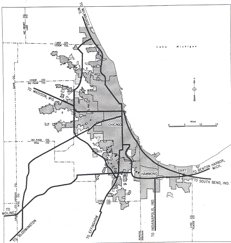
The historical roads were digitized from Shell Atlases in 1951 and 1956, hosted by the David Rumsey Historical Map Collection. This shapefile was constructed by re-aligning modern roads (non-Interstates) to be consistent with the historical maps. 71 CBSAs are included in the shapefile (noted in the file List of CBSAs).
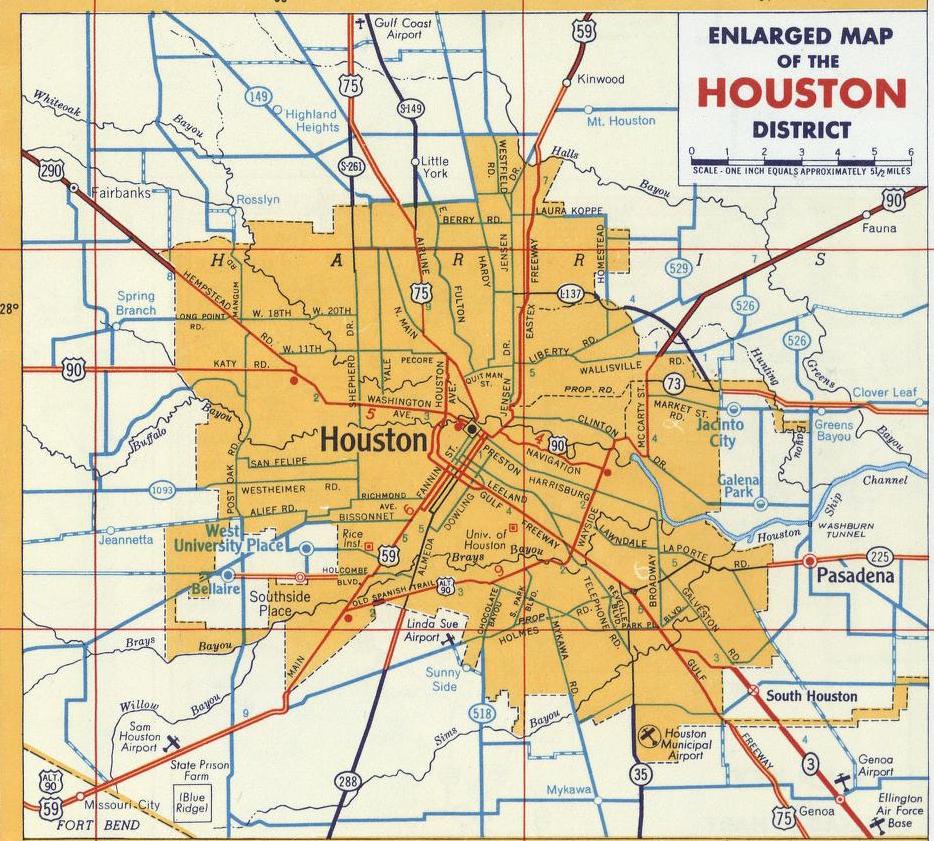
The planned Interstate Highways were digitized from the Yellow Book (General Location of National System of Interstate Highways) maps in 1955. 96 CBSAs are included in the shapefile (noted in the file List of CBSAs). 100 cities have corresponding Yellow Book maps, but some (such as Dallas and Fort Worth) are within the same CBSA.
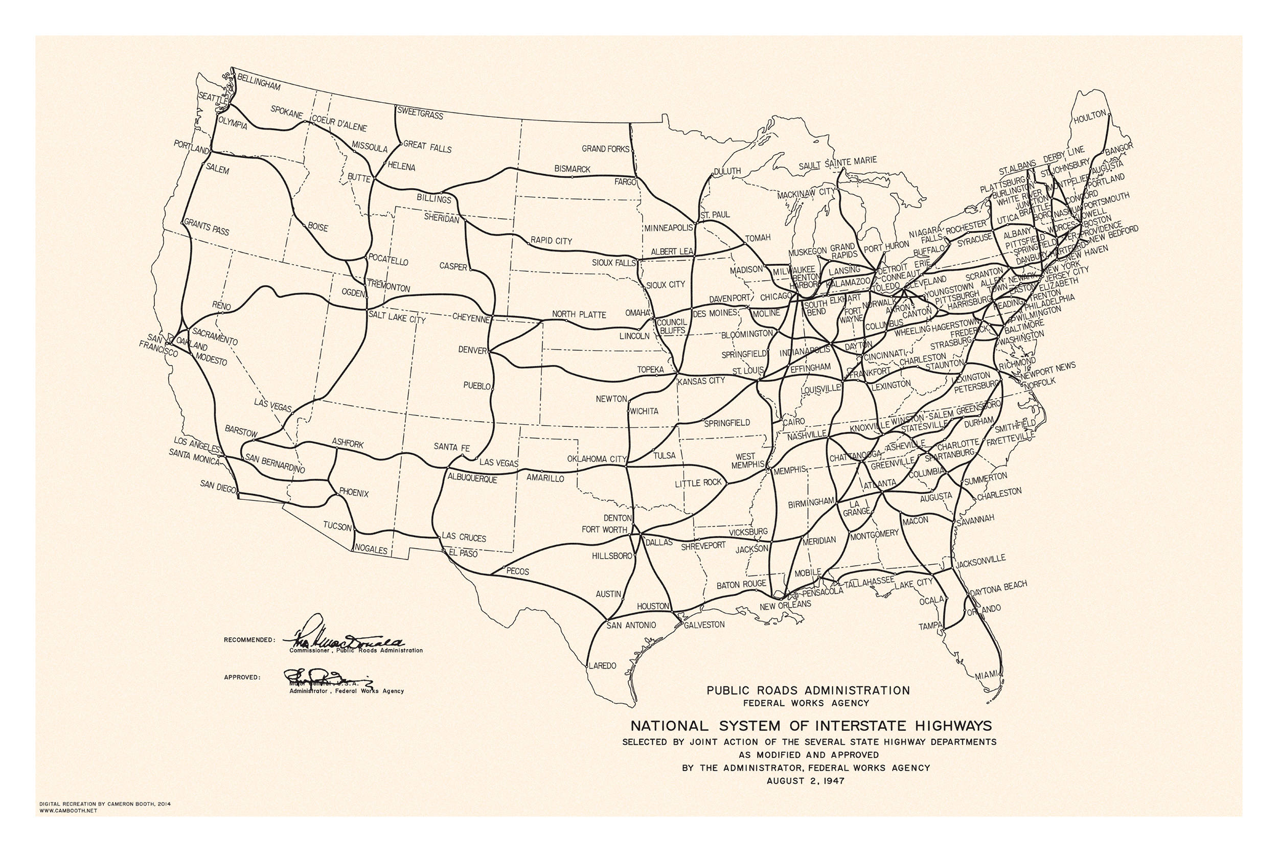
The national Interstate highway plan was digitized from a Public Roads Administration map in 1947. The Yellow Book maps are combined with the 1947 national plan in the shapefile, so this dataset spans the entire country rather than only the 96 CBSAs in the Yellow Book maps.
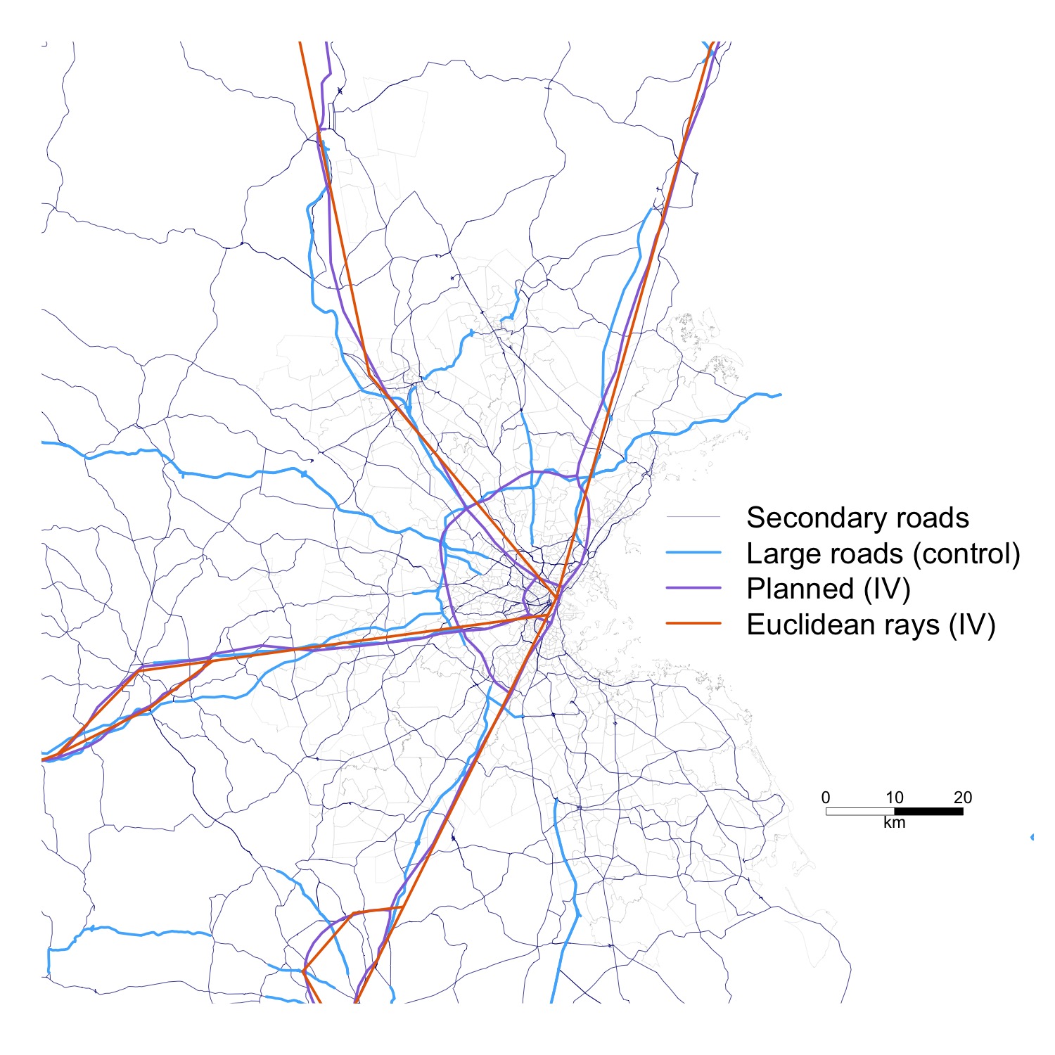
The rays follow the Yellow Book maps and connect intermediate cities/towns along the plans using straight-line rays. 96 CBSAs are included in the shapefile (noted in the file List of CBSAs).